The area encompassing the magnificent landscape of the Escalante River canyons is known as the Escalante Basin and is a small part of the greater province known as the Colorado Plateau. As the plateaus were uplifted by the shifting and buckling of the earth, and the canyons were eroded by meandering streams, a great cross-section of geological formations was eventually exposed. Some of these formations contain the fossils of dinosaur bones, sea shells, land and marine organisms, and the petrified wood of ancient forests.
My first trip to the southwest was back in 2000. On that trip I traveled for two weeks trying to cram in as many locations as I could around the Grand Circle. On my first visit to the Escalante area, I hiked to see Zebra Canyon, Devils Garden and Spooky Gulch. Since that first year, I have been to the Utah area every year at least once and had many more visits to the Escalante area, mainly down Hole in the Rock Road. In the sections below, I will be adding locations and hiking stories as I continue to build out the blog.

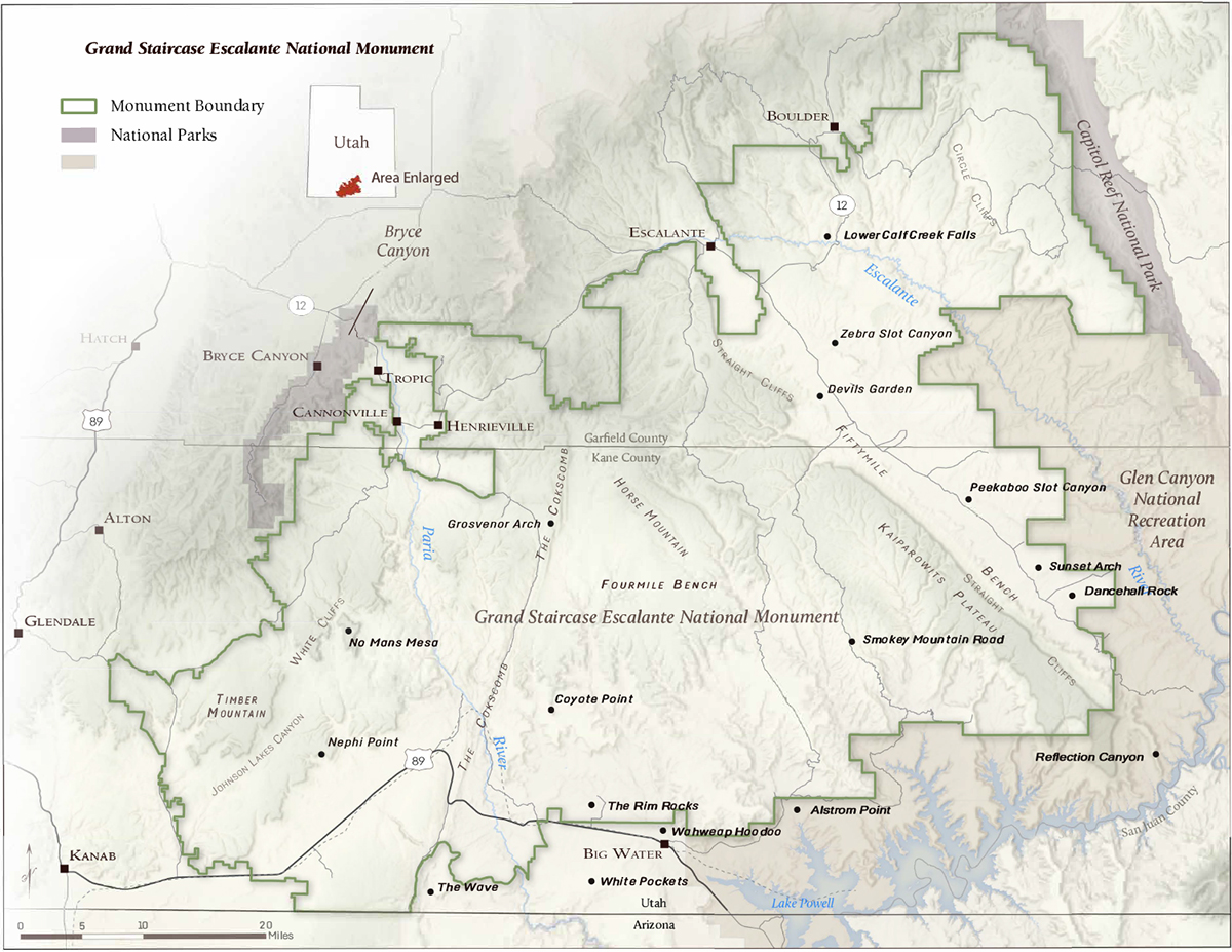
Zebra Canyon
Head east out of the town of Escalante about 5 miles on highway 12 until the well signed Hole in the Rock road.
- Turn onto the Hole In The Rock Road and reset your odometer. ( 12S 453596mE 4175370mN / N37° 43′ 28″ W111° 31′ 36″ )
- Go 8 miles to just after a cattle guard. The trailhead on the south side of the road. This is 0.2 miles before Halfway Hollow. ( 12S 460697mE 4165897mN / N37° 38′ 22″ W111° 26′ 44″ )

Lower Calf Creek Falls
The Lower Calf Creek Falls trailhead is a 15-mile-drive east from Escalante on scenic Byway 12 to Cave Creek Recreation area. If you’re coming from the Boulder Mountain area, the trailhead is about 8 miles west on Highway 12.

Devils Garden
Hole-in-the-Rock Road provides access to this hike. This generally good graded dirt road branches southeast from UT 12, 5.8 miles east of Escalante Interagency Visitor Center and 23.8 miles southwest of the UT 12/Burr Trail Road junction in Boulder. Follow this good wide road southeast, passing a large destination and mileage sign a short distance from the highway. After driving 10.7 miles, pass the signed eastbound road leading to Harris Wash. Continue south on Hole-in-the-Rock Road another 1.6 miles (12.3 miles from UT 12) to the signed spur road leading to Devils Garden, and turn right. Follow this gravel road for 0.25 mile to the spacious parking area adjacent to the picnic site.

Sunset Arch
Head east out of the town of Escalante about 5 miles on highway 12 until the well signed Hole in the Rock road.
- Turn onto the Hole In The Rock Road and reset your odometer. ( 12S 453596mE 4175370mN / N37° 43′ 28″ W111° 31′ 36″ )
- Travel down the Hole in the Rock road for 36.4 miles to the signed 40 Mile Ridge road on the left. (Note: Dance Hall rock is less than a mile past this turn off if you continue down the Hole in the Rock road, and makes an interesting place to visit.) ( 12S 489833mE 4135054mN / N37° 21′ 44″ W111° 06′ 53″ )
- Follow the 40 Mile Ridge Road road for 4 miles to a tee where a short, steep road goes up the hill on the left to the Coyote Gulch trailhead. This is the trailhead. Any vehicle should be able to reach the trailhead in most conditions. ( 12S 495706mE 4138453mN / N37° 23′ 34″ W111° 02′ 55″ )

Spooky Gulch
Head east out of the town of Escalante about 5 miles on highway 12 until the well signed Hole in the Rock road.
- Turn onto the Hole In The Rock Road and reset your odometer. ( 12S 453596mE 4175370mN / N37° 43′ 28″ W111° 31′ 36″ )
- Go down the Hole in the Rock road 26.5 miles to the signed Dry Fork Trailhead road on the left. ( 12S 480188mE 4146664mN / N37° 27′ 60″ W111° 13′ 27″ )
- Follow this road 0.7 miles to a junction where you go left (road #252) ( 12S 481239mE 4146571mN / N37° 27′ 57″ W111° 12′ 44″ )
- Another half mile to the end of the road is the trailhead. ( 12S 480523mE 4147775mN / N37° 28′ 36″ W111° 13′ 13″ )

Dance Hall Rock

Reflection Canyon
Read about Reflection Canyon area here.
https://www.outdoorproject.com/united-states/utah/reflection-canyon
by Kathleen Buenviaje

Grosvenor Arch

Smoky Mountain Road
The Smoky Mountain Road is a designated scenic backway for the world-renowned and very popular Utah Route-12. The Smoky Mountain Road passes through the heart of the Grand Staircase-Escalante National Monument (GSENM), Spanning nearly 1.9 million acres.
Read more about Smokey Mountain Road here.
Smokey mountain road
by Mello Mike


